Kayaking 146 miles
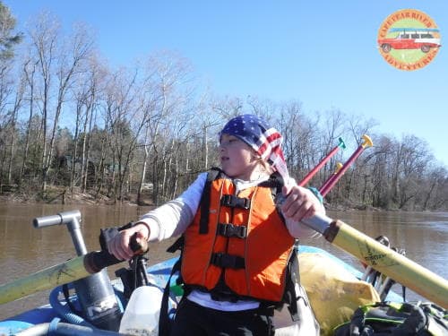
7 year-old can do it, and you can too!
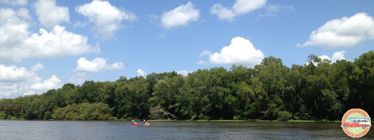
If you are up for an unforgettable experience, the trip from Lillington to Wilmington, NC might be for you! Lillington to Wilmington is a 146-mile trip that offers an amazing natural transition of changing river ecosystems. From Piedmont to Coastal regions, a variety of landscapes and endless wildlife in water, on land, and in the air. Submerge into nature with primitive accommodations. Paddle remote sections of the river and face the challenge of a “thru-paddle”. One thing is for sure, you will remember this experience for the rest of your life: the challenge, the sightseeing, and the accomplishment!
Trip Planning
Every kayaker or canoer has different skill sets, equipment, and goals. This paddling guide is provided with no guarantees and based off of personal first-hand experience and preferences. Our only hope is that it helps you prepare and plan your own trip. A handy guide, if you will :-) River levels and conditions described at all in this guide assume that the water is at a summer normal level (~1.5ft by Lillington's gauge). You should consider this trip only if the following holds true:
- You have a fair amount of paddling experience
- You are in good physical shape. Long distance paddling experience is not necessary.
- Your primary goal is to paddle (not fishing, per se)
- You have some experience backpacking (at least 1-2 nighters)
Plan to paddle 20 to 25 miles per day at the most. If you are paddling a canoe you can shoot to average 2.5 - 3mph. That will put you paddling 8-10 hours per day. Add another 1-1.5 hours for breaks and lunch. Add another hour to find overnight camping and to set up the camp. That's your day on the river; every day for the next week!
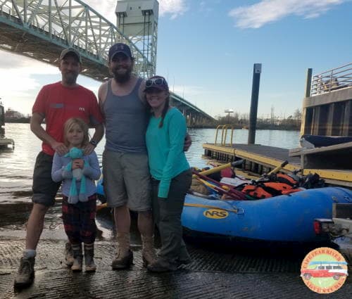
Lillington to Wilmington! Dram Tree Park. January 2019
ilia, Charlotte, Allen, Jordan.
There is NO designated camping along the way!
There is an RV park at Lock 1 (see river sections) where you could pitch a tent,
otherwise all camping must be done in a primitive fashion on the riverbanks!
A lot of times the riverbanks are quite muddy and challenging to find a good, flat, dry spot to camp on.
Using a hammock will make your life during this trip easier and likely more comfortable!
If you see a spot that you think will be a nice overnight stop - take it!
It's vital to set a time-frame for each day when you will start looking for a camping spot and also for when you
absolutely have to get out of the water.
For example, if it gets dark at 6pm, start looking for your camping place at 4:30pm and no matter what get out of the river by 5:15pm
to allow enough daylight to set up camp. Finding a spot and setting up in the dark on a muddy riverbank sucks!
Keep in mind you are in the middle of the woods: poison ivy, tons of thorn bushes, mud, etc...
Plan for at least 8 days to complete the trip, with 7 days paddling and 1 extra day for unforeseen events.
There are 3 Lock and Dam structures that you will have to port around. They are long portages (~300 yards) and having
to carry all the gear and your boat will take some time!
By the time you get to Wilmington, you will be sore and tired - for sure! But with adequate planning and proper food intake,
it is a great adventure!
Don't exhaust yourself on day one with unrealistic planning.
If you are limited on time just do a shorter section; you'll be glad you did!
You can always give us a call to get assistance with trip planning.
Gear
Below is a list of suggested gear. In fact, canoe camping gear is very similar to backpacking gear with 2 exceptions: You have more flexibility on space and weight, but don't get carried away :). You are going to need a reliable dry storage to protect things like your sleeping bag, spare/night clothing, and a few other essentials you'll want to keep dry.
Canoe or Kayak
- Boat of your choice; the longer the better :)
- Life jacket
- Paddle
- Extra back-up paddle
- Rope
- Seat cushion (optional)
Sleeping
- Hammock (preferred)
- Hammock straps
- Rain fly for hammock
- Sleeping bag (might be unnecessary in warmer months, maybe just a light quilt)
- Sleeping pad (optional for hammocks as extra insulation on cold nights)
Cooking
- Stove (JetBoil or MSR personal propane stoves are great; reliable and small.)
- Fuel
- Pot
- Spork
- Water bottle
- Durable travel mug (if planning to drink coffee or tea. Highly recommended for colder months)
Personal items
- Knife
- Flashlight
- Lighter
- Rope (you actually need 2, one for camping and drying clothes and one for the boat)
- Machete and/or ax
- First aid kit
- Fire starter sticks (finger size stick can make a huge difference in rain or with wet river wood)
- Magnesium fire starter (nice back up to have!)
- Toothbrush & toothpaste
- TP
- Extra TP :)
- Small hand sanitizer
- Trash bags (grocery bags work great)
- Body wipes (optional)
Clothing (cold months)
- Layered clothing and rain gear is key! At least 2 sets of everything is important (maybe with exception of outer jacket) in case you get soaked!
- Boots (riverbanks are muddy!! Waterproof boots are great if you got 'em)
- Wool socks
- Warm pants (denim not suggested, hiking pants with under-layer preferred)
- 3 layers for torso. NO cotton. T-shirt, fleece, jacket
- Hat (toboggan preferred)
- Rain jacket
- Rain pants
- Flip-flops or sandals (optional, but extra handy around campsites)
- Spare clothing: pants, 2-3 t-shirts, 2-3 pairs of socks, fleece, underwear
Clothing (warm months)
- Boots or sandals or both
- Socks
- Pants or shorts (pants preferred to avoid use of sunscreen)
- T-shirt (long-sleeves preferred to avoid use of sunscreen)
- Hat (bucket hat is a good idea to avoid use of sunscreen)
- Rain jacket & pants (optional, if it's warm enough you might not need rain gear)
- Spare clothing
Food and drinks
- Below are some suggestions, not a full menu :)
- Try to avoid coolers (they are heavy, take up a lot of room and ice will melt eventually!). Although, if you take one your options are much broader.
- 1 gallon of water per day per person. You may be able to refill water at Locks and Dams. Start with at least 4-5gal. Gallon jags work great.
- Freeze-dried, pre-packaged meals are an easy option but can be expensive
- Top Ramen noodles are super easy & great after a long day
- Canned meats and fish
- Variety of nuts
- Dried fruit
- Nutrition/granola bars
- A few pieces of fresh fruit and veggies is always a nice addition!
- Salt, pepper and most importantly sriracha :)
Bags
- All of the above should fit in 2-3 bags:
- Dry bag that contains sleeping bag and dry clothes
- Backpack with the rest of the gear that can get damp or wet
- Bag with food (can be combined with gear bag)
- Gallon water jug can just "free float" in your boat
River Sections
| Mile | River Feature | Description | ||||||||||||||||||||||||||||||||||||||||||||||||||||||||||||||||||||||||||||||||||||||||||||||||
| 0 | Lillington, NC |
Your journey begins! Find the ramp at Cape Fear River Adventures: 100 South Main St. Lillington, NC 27546.
This is possibly the most dangerous and challenging section of the river! Be absolutely sure to check water levels before launching! This section contains Class I-II rapids that become Class III at higher water levels, which is very common in the spring time, but can happen anytime throughout the year. Your trip will be cut short if you find yourself in a Class III with a loaded canoe... At normal water levels (~1.5ft by Lillington's gauge), this section is rocky with several shallow Class I and II rapids. Test your steering skills dodging the rocks :) Don't worry, the river will get deeper soon! |
||||||||||||||||||||||||||||||||||||||||||||||||||||||||||||||||||||||||||||||||||||||||||||||||
| 10 | Erwin, NC | Developed river access with a ramp is on the river-left, BEFORE the NC-217 bridge. A good spot for a break. This section contains some rapids, mostly Class I's; still shallow. Campbell Falls is right below the bridge 217 in Erwin, NC. Keep left for smaller rapids, or go right for more action! | ||||||||||||||||||||||||||||||||||||||||||||||||||||||||||||||||||||||||||||||||||||||||||||||||
| 14.5 | Lower Little River | Catch a glimpse of the Lower Little River flowing into the Cape Fear River on your river-right. Still shallow, few Class I rapids here and there, although they are becoming more seldom. If rocks and rapids presented challenges along the way, this might be a good section to start looking for a camp spot. Should be a pretty easy find on this river section. In either case, camp before Highway 295 (mile 28.8) where the banks become much steeper and it's much more "city like" as you approaching Fayetteville, NC. | ||||||||||||||||||||||||||||||||||||||||||||||||||||||||||||||||||||||||||||||||||||||||||||||||
| 20.4 | Old Bluff Church Rd |
This is a primitive access point next to the Church from 1700's on the river-left banks.
Unfortunately, it seats about 110ft up a strenuous and steep hill; the access point is not marked and rarely ever used.
Therefore it's nearly impossible to spot unless you are using GPS.
River starts to get effects from the third Lock-Dam (first one that you will encounter, they are numbered from the ocean up). There will be no rapids for the rest of the trip, since the rest of the river is dammed. Got to love flat water paddle! |
||||||||||||||||||||||||||||||||||||||||||||||||||||||||||||||||||||||||||||||||||||||||||||||||
| 28.8 | Highway 295 | Every time you see a bridge you get a feeling of accomplishment, satisfaction, and excitement! There will hand full of them to come... Pass railroad bridge before I-95 Business. | ||||||||||||||||||||||||||||||||||||||||||||||||||||||||||||||||||||||||||||||||||||||||||||||||
| 35.5 | I-95 Business / US 301 Bridge |
Botanical Garden on river right after the bridge. As you approach Person St. in Fayetteville, NC you will see 3 bridges back to back. Check out sunken ship on the river-right. Homeless camp under the bridges in Fayetteville might be likely, where you might get a bargain on a freshly caught catfish... |
||||||||||||||||||||||||||||||||||||||||||||||||||||||||||||||||||||||||||||||||||||||||||||||||
| 36.3 | Person St. |
Nice access point on your river-left.
There is the journey's only store and restaurant on top of the parking-lot! Enjoy :)
Once you depart, you will see remains of some factory with river operations on your river-right. Look for ship mile markers as they will start appearing on the river-left. |
||||||||||||||||||||||||||||||||||||||||||||||||||||||||||||||||||||||||||||||||||||||||||||||||
| 39.9 | Wilmington Highway (Wildlife access) | If you took a break at Person St. you will probably just paddle past this ramp. | ||||||||||||||||||||||||||||||||||||||||||||||||||||||||||||||||||||||||||||||||||||||||||||||||
| 40.9 | I-95 Bridge | Start looking for a "night 2" camping spot about a mile after the bridge to skip on all the highway noise. Banks are steep here and might require a 10-15ft climb up. | ||||||||||||||||||||||||||||||||||||||||||||||||||||||||||||||||||||||||||||||||||||||||||||||||
| 42.9 | Rockfish Creek | Creek on the river-right | ||||||||||||||||||||||||||||||||||||||||||||||||||||||||||||||||||||||||||||||||||||||||||||||||
| 56.3 | Huske Lock and Dam (Lock #3) |
Do NOT go over the dam!!! It is a deadly hydraulic!
This lock is in rough shape, especially after Florance. The officials talked about taking it down but it has been sitting as is for quite some time now. Their phone #: 910-483-7746, no sure if operator available. Port on the river-right, right before the lock. Take out is rough... Warm up before carrying all the gear and your boat for about 200-300 yards. This lock does NOT have water or bathroom access. |
||||||||||||||||||||||||||||||||||||||||||||||||||||||||||||||||||||||||||||||||||||||||||||||||
| 63.3 | Tar Heel Ferry Rd. | |||||||||||||||||||||||||||||||||||||||||||||||||||||||||||||||||||||||||||||||||||||||||||||||||
| 67 | A creek on river-right | |||||||||||||||||||||||||||||||||||||||||||||||||||||||||||||||||||||||||||||||||||||||||||||||||
| 75.3 | Wastewater plant | |||||||||||||||||||||||||||||||||||||||||||||||||||||||||||||||||||||||||||||||||||||||||||||||||
| 77.7 | US 701 Bridge and Wildlife ramp | Welcome to Elizabethtown! This is the closest reference to the halfway-point! Nice park and Wildlife river access on the river-right. Excellent spot for lunch! Eat all you can because you will burn some calories carrying your stuff around the Lock #2 that's coming up in a couple of miles! | ||||||||||||||||||||||||||||||||||||||||||||||||||||||||||||||||||||||||||||||||||||||||||||||||
| 79.4 | Lock and Dam #2 |
Do NOT go over the dam!!! It is a deadly hydraulic!
This lock has the same set up as Lock #3. Port on the river-right, just before the lock. This lock and dam is also behind on maintenance, but it should have a functional bathroom and drinking water! River ramp is at the far end, where you are carrying all your gear. Might be an alternative stop for a break. |
||||||||||||||||||||||||||||||||||||||||||||||||||||||||||||||||||||||||||||||||||||||||||||||||
| 84.9 | Big Sugar Loaf (sandbank) | |||||||||||||||||||||||||||||||||||||||||||||||||||||||||||||||||||||||||||||||||||||||||||||||||
| 90.7 | Walker Bluff | One of the most beautiful river sections. Enjoy large pines on steep riverbanks on the right side. | ||||||||||||||||||||||||||||||||||||||||||||||||||||||||||||||||||||||||||||||||||||||||||||||||
| 102.8 | Elwell Ferry Rd. (Wildlife access) | Nice Wildlife river ramp on the river right. It was closed after Hurricane Florence in 2018, but might be reopened by now (early 2020). You might be tempted to set up a camp here and I don't blame you! It's easy, flat and inviting. Check if camping here is allowed... | ||||||||||||||||||||||||||||||||||||||||||||||||||||||||||||||||||||||||||||||||||||||||||||||||
| 111.5 | Lock #1 |
Do NOT go over the dam!!! It is a deadly hydraulic!
Big milestone here!! Nothing else is between you and the Atlantic Ocean!! Same dam and lock set up here as the 2 locks upstream: portage on the river-right, just before the lock. This dam and lock is much better maintained. It was improved some years ago to accommodate fishing demand. Enjoy bathrooms and some fresh water. You are likely to see some fisherman and boat traffic below the dam. H to H RV Camping (910-520-5756) is located above the lock up the parking lot. Important: Some careful planning is needed here due to ocean tides! Shortly, the river will be becoming more and more swampy and brackish with effect of ocean tide and camping is nearly impossible. By now you should be well aware of how many miles you can do per day. You are only 35 miles away from Wilmington! You need to plan where you are going to camp before making the last leg of your adventure. Plan for the ocean tides! As you get closer to Wilmington and the Atlantic Ocean, the more a rising and falling ocean tide affects your paddling abilities and experience. It can make paddling nearly impossible and extremely tiring if you attempt to paddle when the tide is coming in. Camp a few miles past NC 11 but before Riegelwood paper plant. Plan on a long day ahead of you as you are finishing up the trip. Make sure to check Wilmington's tide table beforehand and allow some offset time for water to rise upstream from ocean. |
||||||||||||||||||||||||||||||||||||||||||||||||||||||||||||||||||||||||||||||||||||||||||||||||
| 113.6 | NC 11 Bridge | |||||||||||||||||||||||||||||||||||||||||||||||||||||||||||||||||||||||||||||||||||||||||||||||||
| 119.6 | Reigelwood paper mill |
You will start hearing the plant a couple miles ahead.
It stinks as you get closer.
For the next several miles past the mill you should be ok paddling as before. But before long you will start seeing river splits, different channels, and other confluences. It's best to use GPS for the rest of the trip not to pick up unwanted miles... hint: make sure your phone is fully charged! |
||||||||||||||||||||||||||||||||||||||||||||||||||||||||||||||||||||||||||||||||||||||||||||||||
| 131.3 | Black River | As you approach Wilmington, go under several bridges. There is another big plant on the river left - it's Duke Energy. Merge with another branch of the Cape Fear by the battle ship museum on the river-right. Brush up on the river traffic rules, as you might encounter motor boats and full-size commercial ships here! Paddle next to the river walk, restaurants and stores on the river-left. The take-out is on the river-left before the Hwy 17 bridge. | ||||||||||||||||||||||||||||||||||||||||||||||||||||||||||||||||||||||||||||||||||||||||||||||||
| 145.7 | Dram Tree Park, Wilmington, NC | You DID IT!!! | ||||||||||||||||||||||||||||||||||||||||||||||||||||||||||||||||||||||||||||||||||||||||||||||||
|
References:
Paddling Eastern North Carolina by Paul Ferguson, 3rd edition. Thank you Google Maps and MapMyRun.com |
||||||||||||||||||||||||||||||||||||||||||||||||||||||||||||||||||||||||||||||||||||||||||||||||||